Navigating a new campus is all part of the nostalgic movie montage that is freshman year of college. The changing leaves! The quaint Gothic architecture! The… drone tour guide? That’s the concept behind Skycall, a playful prototype that’s designed to help visiting Harvard students find their way around MIT’s notoriously confusing campus—which has been called “one of mankind’s most difficult and disorienting labyrinths.”
Skycall is the work of the Senseable City Laboratory, an MIT research group that explores how sensor technology can be deployed to help make cities smarter. As the lab’s director Carlo Ratti explained to me, the idea for Skycall came from a common sight on MIT’s campus (where Harvard students can take classes). “All these Harvard students are always getting lost at MIT,” he says. “If you’re not familiar with it, it’s very hard to navigate, and we wondered how we could give them a hand.”
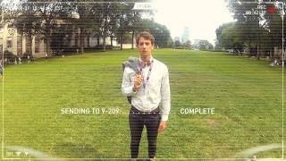
In theory, the Skycall quadcopter is equipped with all the hardware necessary to find, communicate with, and track the intended target… er, student. The UAV is summoned using a custom-built app that serves as Skycall’s nerve center. After finding the intended user with its onboard GPS system and camera, Skycall can speak with the student using its audio system and microphone. It’s also possible to pause the tour via the app, or even cut it short. “Rather than the visitor diverting their attention to a map, the autonomous guide provides an intuitive navigational system of simply ‘following’,” commented project lead Chris Green.
Skycall sounds like a marketing stunt, and in a way, it is—for the Senseable City Lab’s broader work with UAVs. For Ratti and his team, drones represent a valuable tool that’s mainly been leveraged to do harm, both through warfare or surveillance. “Our imaginations of flying sentient vehicles are filled with dystopian notions of surveillance and control, but this technology should be tasked with optimism,” says Yaniv Jacob Turgeman, who heads up R&D for the lab, over email. “The urban UAV will guide us in disorienting situations, support search and rescue efforts, track environmental problems, and even act as digital insects re-introducing natural biodiversity to our man-made environments.” For example, one upcoming Lab project will use UAVs to sample air and water quality around Boston. “They’re are a way to help us better understand our environment,” Ratti adds.
So while the prototype is more of a concept than a workable app, it’s a playful way to hint at how drones—a technology with a massively negative public image—could ultimately play a positive role in American cities. Though maybe not every American city.
https://gizmodo.com/demand-for-drone-hunting-licenses-overwhelms-tiny-color-1263694045