While studying the deadliest landslide in U.S. history—the 2014 Oso disaster that killed 43 people in Washington’s Steelhead Haven neighborhood—Joseph Wartman found himself perplexed. While most of his team members looked up at the slope to understand what triggered the landslide, he fixated on the lower part of the slope, where Steelhead Haven lay buried.
“How did this neighborhood come to be? Did people understand how risky a place it was? What resources did they have on hand?” he recalls asking himself. Wartman, director of the Natural Hazard and Disaster Reconnaissance Facility (RAPID) at the University of Washington, told Gizmodo in an email that he still thinks about these questions a lot. In a study published today in the journal Earth’s Future, he and his colleagues provide Americans with potentially lifesaving information about the landslide hazard in their neighborhoods. To the researchers’ knowledge, it is the first study to map landslide hazard zones on a national scale.
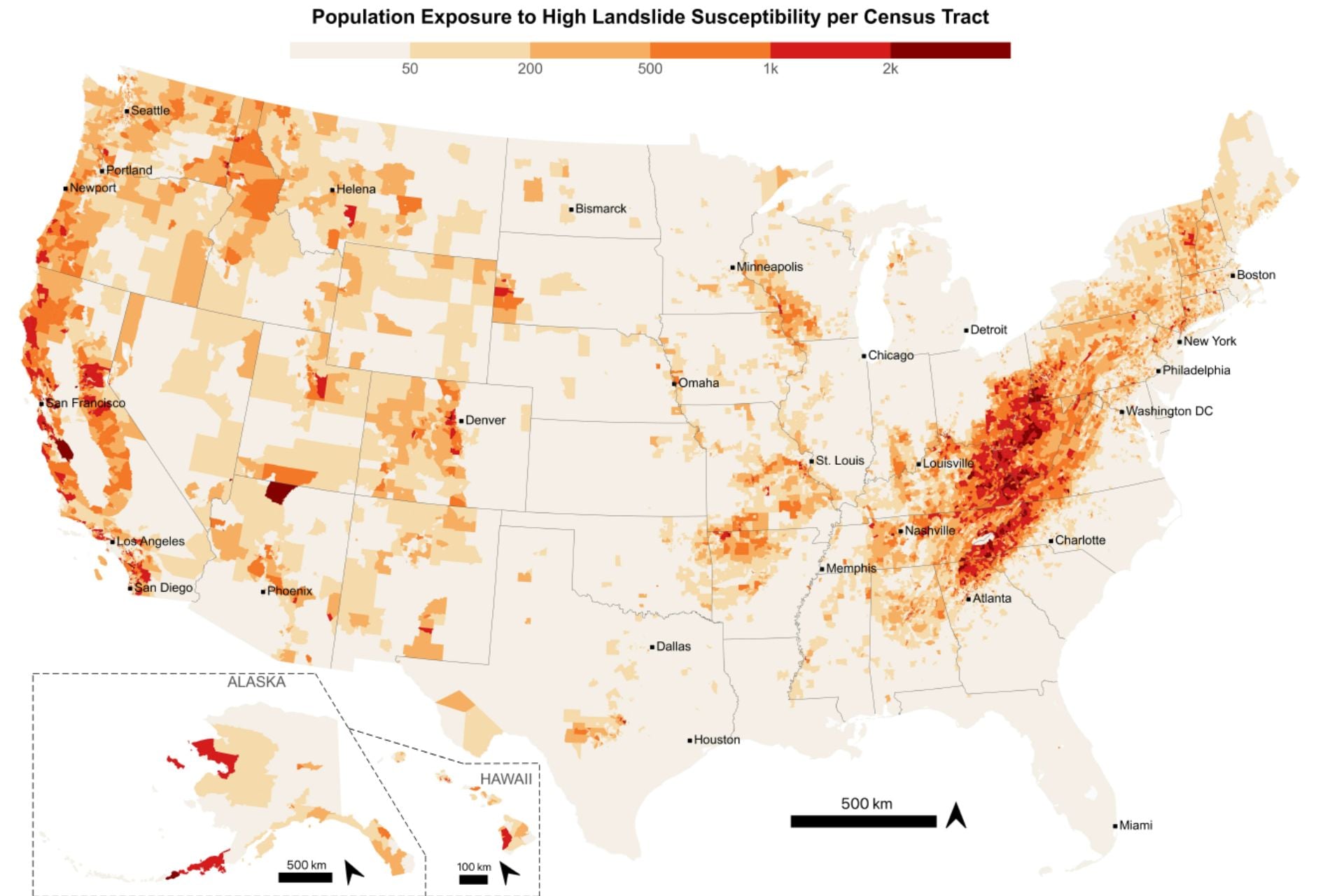
The findings revealed that 6.5 million Americans live in landslide-prone areas. While these disasters are typically associated with the West, where the terrain is steeper and larger, destructive landslides are more common, the researchers found that over half of people exposed to landslide hazards live closer to the East Coast.
“In some of my earlier research, we found that very simple measures can help someone survive a landslide,” Wartman explained. “Some of these things are simply about having an awareness of landslide risk, or knowing that you’re in a landslide hazard area and having a plan for what to do if the ground gives way. This knowledge can increase the odds of survival by a factor of 10 or more.”
Know your risk
To systematically quantify landslide exposure on a national scale, Wartman and his colleagues combined maps of landslide-susceptible areas from the United States Geological Survey (USGS), spatial footprints of every recorded building in the U.S., and nighttime building occupancy estimates to quantify the number of people inside those that could be struck by landslides.
“Over the past several years, the Census Bureau has released some excellent data products that allow us, for the first time, to really understand who is at risk,” Wartman said. “This coincides with databases that have recently been published identifying the locations of individual buildings across the entire United States. Together, these data have finally enabled us to study the human geography of landslides.”
The researchers used nighttime occupancy estimates because that’s when people are least likely to react to a hazard and safely evacuate, but it’s worth noting that this approach did not allow them to consider daytime movements, such as tourists flocking to scenic slopes. The study doesn’t account for landslide frequency either, which tends to be higher in the West.
Still, this work revealed important information about landslide hazard hotspots at fine scales. That’s important because landslide susceptibility at one location can be vastly different than that of a location just a few dozen feet away. The study also honed in on an urban-rural divide, finding that rural residents—who account for 62% of people living in landslide territory—are less able to recover from these disasters.
The map highlights significant landslide hazards across much of the East, particularly in the Appalachian Mountains. “We have a perception of landslides being a West Coast issue largely because the media tends to report on large, spectacular landslides that make great stories,” Wartman explained. “Landslides occur frequently in the East, but often as many smaller individual events. We became aware of East Coast landslide potential only recently, with the tragic hurricane debris flows that killed many people.”
In 2024, Hurricane Helene triggered more than 2,000 landslides in less than a week, according to the USGS. One of the deadliest occurred in the community of Craigtown in Fairview, North Carolina, where at least 10 smaller landslides converged into a destructive channel that destroyed homes and claimed 13 lives.
Wartman believes Hurricane Helene raised awareness of landslide hazards in the East, but he hopes this new study will broaden that awareness. “As part of this work, we have made an easily accessible database that enables members of the public to query our data, so that communities can begin to understand their localized hazard,” Wartman said. “We hope that a broader outcome of this work is greater knowledge of landslide hazards across the entire United States.”
Climate change could increase landslide risk
This knowledge will become increasingly valuable as the planet warms.
Climate change is exacerbating prolonged drought, severe precipitation, and wildfire across the United States. Each of these weather extremes interacts with landslide risk in different ways. Research has shown that drought can actually halt some slow-moving landslides, according to Wartman. “But more commonly, we are concerned with the increasing frequency of severe precipitation events across the U.S., which often result in fluid-like, fast-moving debris flow-type landslides that can be very dangerous to people,” he explained.
Wartman is especially concerned about the cascading effect of summer wildfires, which prime the landscape for landslides triggered by heavy precipitation in the fall. That’s because severe wildfires destroy soil-stabilizing plant root systems, create water-repellant soil layers, and remove canopy cover.
Going forward, he hopes this study will help experts develop landslide preparedness and prevention strategies that are tailored to individual communities. “The questions are, how do we reach these different communities, and what mitigation and risk communication products are appropriate for these communities?” he said.