With the strongest El Niño on record still intensifying, this climate phenomenon is bound to have a major influence over winter weather across the United States. The National Oceanic and Atmospheric Administration (NOAA) released its official seasonal outlook yesterday, and it looks like the country can expect some classic El Niño weather patterns.
The temperature and precipitation forecasts, which span December 2026 to February 2027, generally predict warmer-than-average temperatures across the northern tier and wetter than average conditions across the southern tier, much of the West Coast, and the Eastern Seaboard. That’s the exact setup one would expect to see during El Niño, which shifts the jet stream southward over the nation.
But this forecast comes with caveats. First, this 90-day outlook does not predict actual temperatures or precipitation amounts for the upcoming season. Rather, it describes the likelihood that the season’s average temperature and precipitation will be above normal, near normal, or below normal, and how drought conditions are likely to change in the months ahead.
Second, every El Niño unfolds differently. While stronger events tilt the odds toward expected weather outcomes, even the most powerful El Niño ever observed cannot guarantee specific impacts. In fact, forecasting the effects of the 2026-2027 El Niño may be complicated by climate change and the fact that neither scientists nor climate models have ever seen an event of this magnitude before.
Still, NOAA’s seasonal outlooks are based on extensive historical weather data and state-of-the-art forecast modeling, so they offer a highly informed perspective on how the season might unfold. Without further ado, let’s dive into the maps.
A mild winter for the Northern US
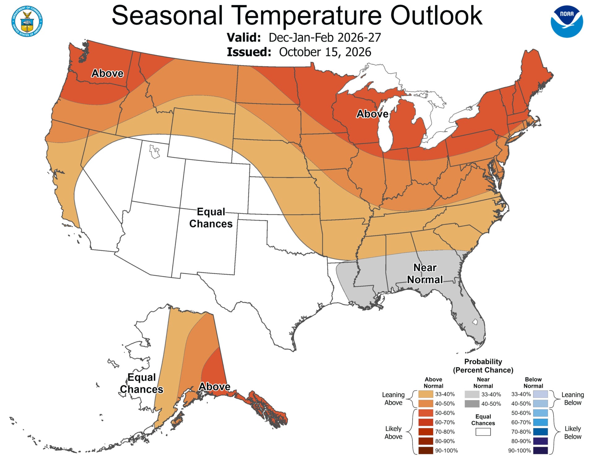
NOAA’s season temperature outlook shows a high probability of above-average temperatures across northern California, the Pacific Northwest, the Midwest, the Mississippi Valley, much of the East, Alaska, and for Puerto Rico and the U.S. Virgin Islands.
Meanwhile, near-normal temperatures are most likely for parts of the Southeast from Louisiana to Florida, and Hawaii and much of the Southwest have equal chances of below-average, near-average, or above-average temperatures.
Again, this is a typical setup for an El Niño year, but El Niño isn’t solely responsible for the increased likelihood of above-average winter temperatures across more than half of the country. As global temperatures rise due to fossil fuel emissions, research has shown that winter is warming faster than any other season for the majority of the United States. El Niño temporarily exacerbates the effects of this long-term, human-driven trend.
Drought relief for the South
According to the U.S. Drought Monitor, a whopping 45% of the nation is currently in drought. The most severe conditions are concentrated in south-central and western states, but fortunately, El Niño could bring some relief.
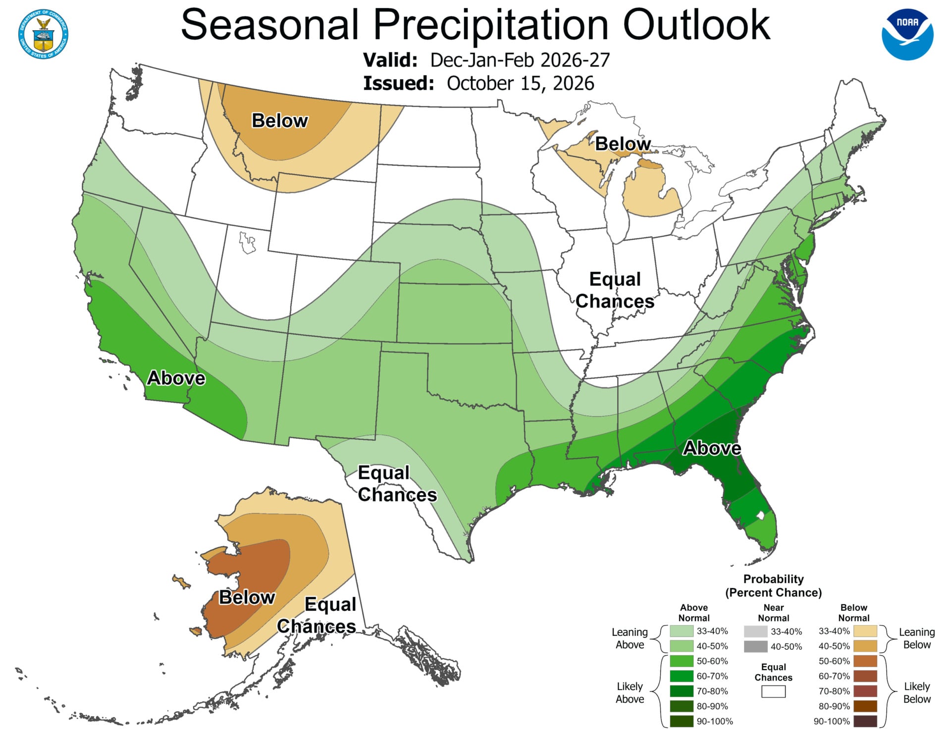
Wetter-than-average conditions are most likely across the southern tier, particularly in Southern California, southwestern Arizona, and along the Eastern Seaboard from the Gulf Coast to the Mid-Atlantic. However, increased likelihood of above-normal precipitation stretches as far north as the Pacific Northwest and southern Maine.
Hawaii, much of Alaska, the northern Mountain West, parts of the Great Lakes, and the western Pacific Islands are most likely to see dryer-than-average conditions. And the Intermountain West, northern Plains, Ohio Valley, and Puerto Rico and the U.S. Virgin Islands have equal chances of below-average, near-average, or above-average precipitation.
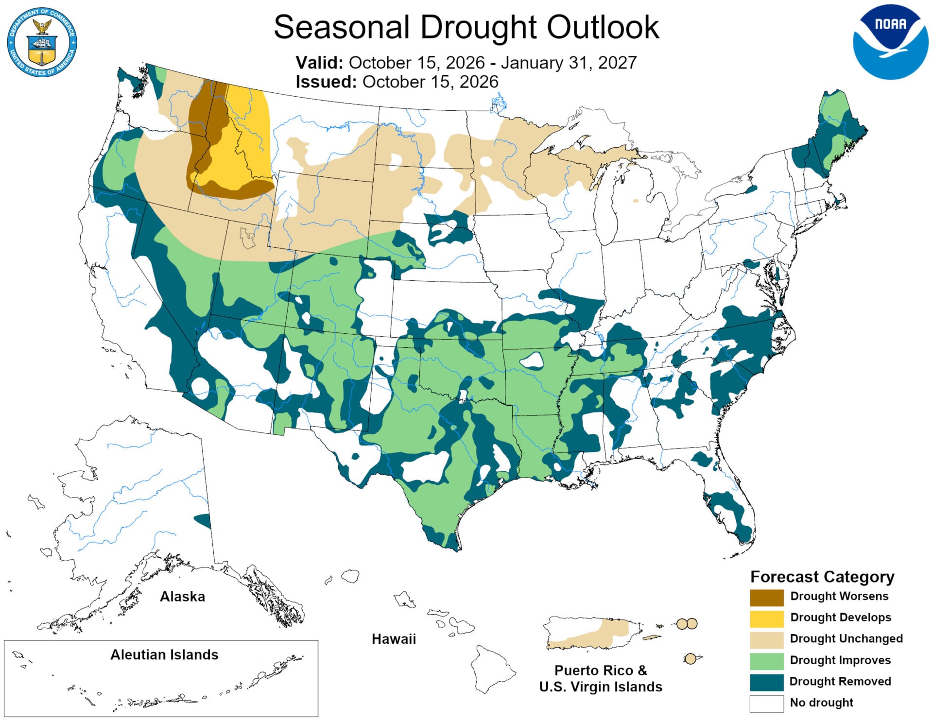
NOAA expects drought conditions to improve—or potentially disappear—in the Southwest, southern Great Plains, Southeast, and parts of the East Coast. After this past winter’s historic snow drought and a record-hot summer, major basins such as the Colorado River and the Lower Mississippi River desperately need rain. But the increased likelihood of elevated precipitation will come with a risks, too.
“While higher chances of rain and snow may bring relief to drought-afflicted areas, too much precipitation on dry soil can fuel destructive flash floods and mudslides,” said Ken Graham, director of NOAA’s National Weather Service. “Now is the time for communities and individuals to plan ahead for the upcoming winter.”
Meanwhile, drought conditions could develop or worsen across parts of the northern Rockies as well as northeastern Oregon and eastern Washington.
Again, it’s unlikely that the season will unfold exactly as this outlook describes, but the forecast can help states plan for expected temperature and precipitation trends. With a super El Niño and climate change simultaneously influencing U.S. weather, it could certainly be a wild season.