Less than a week after a freak tornado outbreak, meteorologists are again gawking in awe and horror at the scenes unfolding on their radar screens and across the Midwest and Plains.
A powerful windstorm unleashed by the clash of record heat and a vigorous storm system dropping out of the Mountain West has unleashed chaos for a huge swath of the United States. Raging winds have whipped up to 107 mph (172 kmh) in Colorado, fires have lit up the Texas Panhandle, and monster plumes of dust have turned night into day from Nebraska to Kansas.
As if that wasn’t enough, a line of thunderstorms is now screaming into the region with shocking speed and ferocity—and could be poised to unleash a handful of tornadoes in locations usually covered in snow at this time of year. Dealing with one of these hazards alone would be shocking for this time of year, but seeing the weather map painted in broad brush strokes with some of the most extreme warnings that the National Weather Service issues is a nightmare.
The Dust Bowl Has Returned to the Plains
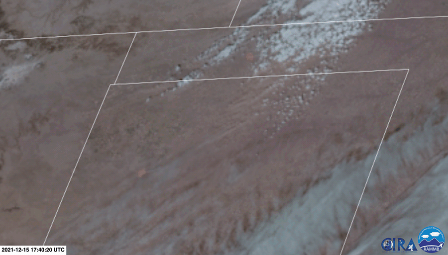
The Plains have been in a snow drought so far this year, and the recent bout of extreme heat has all but obliterated any tiny pockets of snow remaining. Long-term drought in parts of the states where winds are currently blowing means there’s just not much moisture to hold soil in place. Plumes of dust are clearly visible to satellites located more than 22,000 miles (35,405 kilometers) above the Earth’s surface.
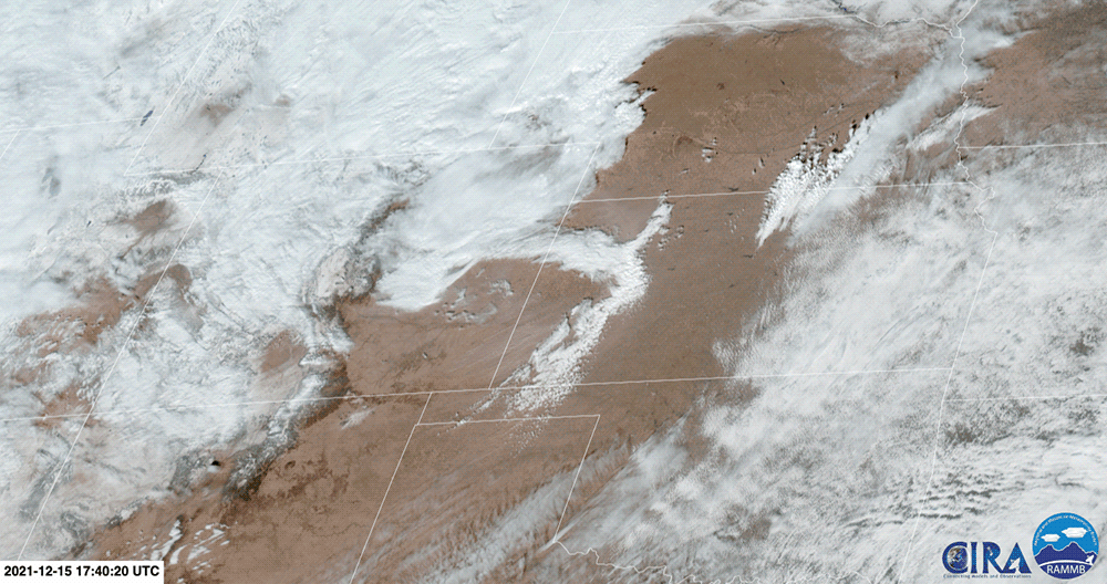
But the real nightmare fuel is what’s happening on the ground. Numerous Twitter users have documented skies saturated with dust. The scenes may look like Hollywood special effects, but this is real life.
"DUST BOWL 2021" This video from Main Street in Elkhart, Kan. is just one example of the severe conditions wind and dust are creating across Kansas. https://t.co/RaVNioniQB #kwch12 #storm12 #kswx pic.twitter.com/n2QJdzX0RJ
— KWCH 12 News (@KWCH12) December 15, 2021
Intercepted the beginning of a dust storm at 9:30a in Lincoln County #9wx pic.twitter.com/EqQwspcmth
— Cory Reppenhagen (@CReppWx) December 15, 2021
The conditions that gave rise to the Dust Bowl of the 1930s have become twice as likely thanks to carbon pollution from burning fossil fuels. Just something to think about…
Wildfires in December for Texas and Oklahoma
In addition to satellites showing dust, smoke is also visible in the Texas and Oklahoma panhandles. Wildfires have rapidly spread in the region, covering thousands of acres and forcing evacuations.
The biggest blaze is the Parker Creek Fire, located to the west of Amarillo. The fire ballooned to 3,500 acres and was only 10% contained as of Wednesday afternoon local time.
Update: the #ParkerCreekFire in Oldham County is an estimated 3,500 acres and 10% contained. The fire is currently 14 miles long and 1/2 mile wide. #txfire pic.twitter.com/Ii8emTxbNN
— Incident Information – Texas A&M Forest Service (@AllHazardsTFS) December 15, 2021
Monster fires are also spreading in Kansas. Again, this is December.
4:57 pm CT: This is just a 1hr loop of the rapid & extreme fire behavior and spread going on in Kansas. Anyone east of the area should evacuate NOW! #wildfire #kswx #windstorm pic.twitter.com/Fvcl5VokWT
— Brad Panovich (@wxbrad) December 15, 2021
The Dangerous Line of Storms Sweeping East
“I’ve been a professional Met for parts of 6 decades, 47 years. I can say unequivocally I’ve never seen what’s happening now, and will continue into Wed night, this time of year and maybe even peak svr season over this large an area,” former Accuweather meteorologist Ken Clark tweeted.
“Svr” is weather geek shorthand for “severe,” and the season for weather like what we’re seeing is decidedly not December. (It’s usually late spring.) A line of storms has formed and appears to likely be a derecho. It’s pushing across the Plains with straight-line winds of up to 90 mph (145 kmh). Those are different from tornadoes in that they don’t rotate, but instead blow, well, straight. But that doesn’t make them any less of a danger.
The storm system is also moving exceptionally quickly at a rate of 90 mph, which has led disaster managers to crank up warning sirens even with storms dozens of miles away. (Usually, those warnings only come when a storm system is all but right on top of a location.) The storms are also potentially kicking up tornadoes, adding another danger to people in their path.
You ever wonder what one of those crazy lows over the open Atlantic/pacific looks like on radar? Well now you know. #wild pic.twitter.com/sOv1ot7Nyf
— Brandon Black (@backinblack_wx) December 15, 2021
You don’t have to be a radar or satellite image expert to see how intense this storm system is. After raking Nebraska, it will move through Iowa and Missouri where the NWS is warning of “severe/damaging winds” and the possibility of tornadoes.
The shape and energy of a system like this over this part of the U.S. at this time of year is exceptionally rare. If you live anywhere in its path, absolutely heed the warnings from the NWS, disaster managers, and trusted meteorologists. We’ve already seen enough weather-related tragedies this week to last a lifetime.
HOLY COW!!
Here’s a look right outside our station in #LNK. It was hard to even see a few feet in front of you. We heard reports of 93 MPH wind gusts at the Lincoln airport.
Please everyone STAY SAFE! 💨 @Channel8ABC pic.twitter.com/fwrzlgTE3w
— Macy Meyer (@MacyMeyerTV) December 15, 2021