Against all odds, we are not done with Tropical Storm Elsa yet. The early season tropical storm that could is currently drenching the Carolinas in heavy rain, and it’s slated to make a run on the Northeast to end the week.
Elsa has had quite a go of it since first lashing Barbados. The storm became the season’s first hurricane, traversed Cuba’s mountains as a tropical storm, and even restrengthened back into a hurricane briefly before making landfall in Florida as a tropical storm (and shutting down rescue operations at the Surfside condo collapse in the process). It’s continuing to crawl northward and impacts will be felt as far north as Maine in the U.S. The storm is forecast to transition to extratropical and will even make a run at Newfoundland and Labrador over the weekend, keeping Atlantic hurricane season weird.
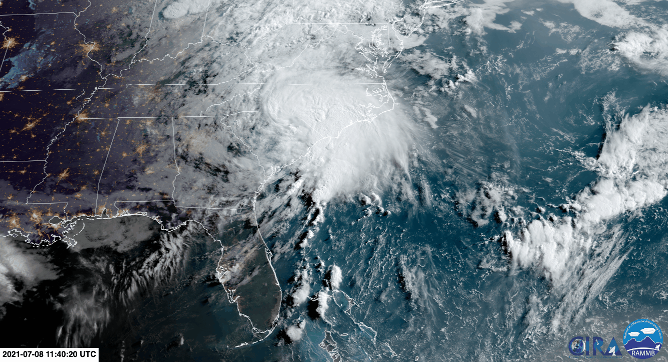
Elsa’s Current Impact in the Carolinas
Unfortunately, Elsa has maintained tropical storm intensity as it crawls up the Eastern Seaboard. Right now, it sits on the border of the Carolinas. Winds have gusted to 54 mph (87 kph) at Myrtle Beach’s airport, and tropical-storm-force winds radiate 115 miles (185 kilometers) out from Elsa’s center, indicating the storm is still packing a decent punch.
The winds could knock out power sporadically—South Carolina is currently reporting more than 11,000 customers without power—but the real concern for the region is rain. Up to 8 inches (20.3 centimeters) are expected, which could lead to some flash flooding. The National Weather Service has issued a flash flood watch for the region as well as points north all the way to Maine. Tornado watches are also in place along the coastal Carolinas, throwing another flavor of hazard into the mix. In short, anyone in the Carolinas and the Mid-Atlantic should be on the lookout for Elsa’s impacts on Thursday.
New York Will Get a Taste of Elsa
Elsa is expected to emerge over open water sometime on Friday morning just off the coast of New Jersey. It will continue marching northward and remain a tropical storm when it reaches New York later that day. The impacts will be moderate, with up to 6 inches (15.2 centimeters) of rain and gusty winds that could turn umbrellas inside out. The National Hurricane Center issued tropical storm warnings calling for “significant” flooding impacts, particularly in urban areas so it’s worth keeping an eye on how storm drains handle (or don’t handle) Elsa’s rainfall.
In a hurricane local statement from the National Weather Service, a relative of the NHC, the agency expanded on that warning, telling those in the New York metro area to prepare for “possible significant impacts across Southeast New York, Northeast New Jersey, and Southern Connecticut” from flooding. The NWS statement added that flooding “may prompt some water rescues,” which is a good reminder to follow the evergreen advice of not driving or wading into floodwaters.
Another potential driver of flooding is the rainfall inundating the area on Thursday ahead of Elsa. Powerful thunderstorms have moved through the region ahead of Elsa, turning day into night in Manhattan and the surrounding area. The storms have brought at least a couple inches of rain to areas Elsa will pass over on Friday. With waterlogged soil and clogged drains, that means the odds of Elsa-related flooding could increase.
These impacts also apply to large areas of New England, including Boston. However, I have intentionally referred to New York because New Yorkers love nothing more than to be the center of attention while the rest of the world loves nothing more than to hate on New Yorkers for being the center of attention. Please feel free to sound off in the comments with your strong opinions about the subheading for this section and/or New Yorkers in general. Here, I’ll start: Yankees suck, let’s go Red Sox.
Extratropical Storm Elsa Will Become a Thing
By Saturday night, Elsa will emerge over the Gulf of Saint Lawrence and likely transition to Extratropical Storm Elsa (sometimes, this type of storm is also referred to as post-tropical). The distinction is merely meteorological. An extratropical storm loses key characteristics of a tropical storm, such as a warm core. But Elsa will still spin, have gusty winds, and bring rain and maybe even some light storm surge ashore to parts of Atlantic Canada. The forecast shows it’s likely to pass just off the southern tip of Greenland as an extratropical storm.
There have been 16 tropical or extratropical storms that have made it to the Gulf of Saint Lawrence in early July or sooner, according to 142 years of data kept by the National Oceanographic and Atmospheric Administration. Six even maintained tropical status. That makes Elsa’s appearance there an oddity for this time of year, but not unheard of. Near Greenland, the number of storms gets a little thinner; only three storms have passed within 230 miles (370 kilometers) of the island before mid-July over the period of record.
Elsa Has Already Made History
That said, Tropical Storm Elsa will be remembered in the history books. For one, it has generated a record amount of terrible Frozen memes. (As someone who does not have children, I don’t understand any of them.) But beyond internet history, Elsa has also set a meteorological mark as well.
Elsa is the earliest fifth named storm ever recorded, breaking the record set just last year. After lashing Barbados and the Lesser Antilles, the storm entered what’s known as the hurricane graveyard in the eastern Caribbean, an area that has seen a whopping two named storms before July 15 in those 142 years of records. Its track from the western Atlantic through the Caribbean and eventually into Atlantic Canada is also unheard of for this time of year.
The weirdness comes on the heels of the most active hurricane season on record, and after NOAA updated its 30-year average for hurricane season to include more storms. Some of this can partially be attributed to satellite and aircraft observations as well as natural climate patterns. But scientists have teased out the role of climate change in increasing the odds of more intense hurricanes and other impacts, including worsening the destructive 2017 hurricane season.
This post has been updated with the latest forecast information and warnings.