The National Oceanic and Atmospheric Administration (NOAA) was using its GOES-13 satellite to capture Hurricane Sandy as it went from being a fierce tropical storm, to a full-blown hurricane this morning when it made landfall on Jamaica. You can watch as the surging clouds slowly begin to cycle around each other, eventually becoming a monster of a geophysical force.
According to NASA:
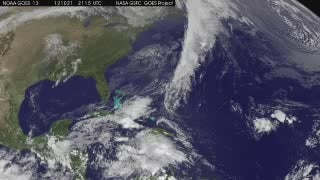
This animation of NOAA’s GOES-13 satellite observations from Oct. 21-24, 2012, shows Tropical Storm Sandy become a hurricane just before making landfall in Jamaica and Tropical Storm Tony form and strengthen in the central Atlantic Ocean. Sandy became a hurricane on Oct. 24 at 11 a.m. EDT when its maximum sustained winds hit 80 mph (130 kph). At that time, it was centered about 65 miles (100 km) south of Kingston, Jamaica.
You can track Hurricane Sandy’s progress via the NOAA website


