An 87-mile-long (140-kilometer-long) stretch of the Rio Grande is so bone dry right now that some local farmers haven’t been able to irrigate their crops in the past two months. And, as soon as next year, the fate of that billion-dollar industry is also coming for portions of the approximately 15 million people who depend on the Rio Grande for the water flowing through their taps at home.
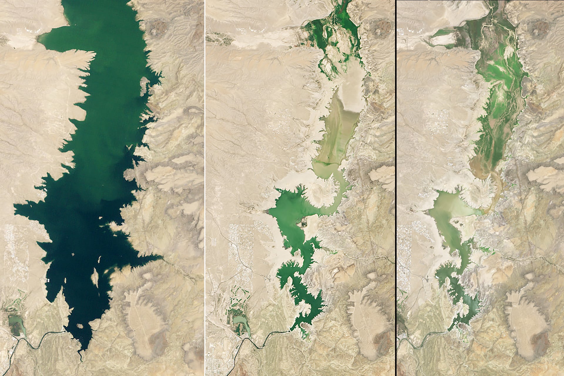
But another way to look at the scope of this problem is that it’s visible from space. Several years of extreme drought—accelerated this year by the earliest snowmelt on record high up where the Rio Grande begins in the southern Rockies—has reduced the Elephant Butte Reservoir to just 1.4% of its total capacity. When it’s full, it’s the largest reservoir in New Mexico. But now Elephant Butte is running drier than it has been in over half a century.
Satellite images obtained via the Thematic Mapper on Landsat 5, which is jointly managed by the U.S. Geological Survey (USGS) and NASA, as well as the Operational Land Imager tool onboard the agency’s Landsat 8 and Landsat 9 platforms, show this vanishing in stark relief. The U.S. space agency released the images alongside comparison shots of the reservoir when it was nearly full in 1994, as well as beside another rough patch of drought for the reservoir and the Rio Grande that feeds it, which left Elephant Butte at 2.9% capacity in 2013.
“There are communities out there that are suffering to a degree that we haven’t seen in a long, long time,” as Middle Rio Grande Conservancy District CEO Jason Casuga told local NBC affiliate KOB 4 this July. According to Casuga, this year could go down as the driest for the river in history.
Space-based intelligence
Fortunately, NASA has been doing more than just photographing the problem from orbit. Multiple projects fostered under the umbrella of the agency’s Western Water Action Office (WWAO) have been developing near-real-time data tools to model regional variables for local farmers, including soil moisture and the rate at which water vaporizes off plants and soil into Earth’s atmosphere.
A key part of the goal is helping farms plan around future droughts, reallocating resources (for example) to crops like drought-resistant corn that might fare better under these punishing conditions than those with heavy water requirements, like alfalfa.
“If we reduce the crop area by 20% and replace alfalfa with corn, water need can be reduced by more 50% compared to [the] current condition,” Vikalp Mishra, a civil engineer and hydrologist at the University of Alabama in Huntsville, explained in his 2025 presentation for this NASA project.
Ground-to-space communication
Another WWAO project, according to NASA, is training satellites to track water surface heights across the desert southwest in collaboration with data collected via drones and more standard ground measurements. On-site spot measurements by people and a variety of ground-based measurement devices like pressure transducers, which measure water elevation, and streamgages, which measure flow rates, could be used to help track how groundwater pumping by various landowners impacts the health of the Rio’s river flow.
NASA says that the new tools WWAO is developing with this training will help managers in administering water rights—a real problem amid extreme droughts, as (with apologies to Daniel Plainview in There Will Be Blood) a lot of landowners are drinking other people’s milkshakes.
And this kind of data is sorely needed, as legal rights aren’t keeping pace with climate reality on the ground. According to Samuel Sandoval Solis, a professor at the University of California, Davis, who tracks water resources issues from the Rio Grande between New Mexico and Texas, the amount of legal rights on the books for the water flowing through the Rio Grande is nearly double the volume of the water that’s actually in the river in recent years.
“That’s why the reservoirs will never refill,” Sandoval Solis told Texas Monthly last month, “that’s why the needle only moves further toward crisis.”