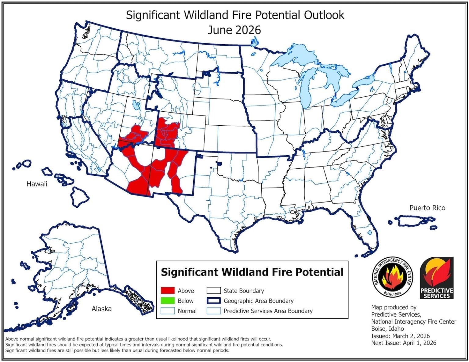
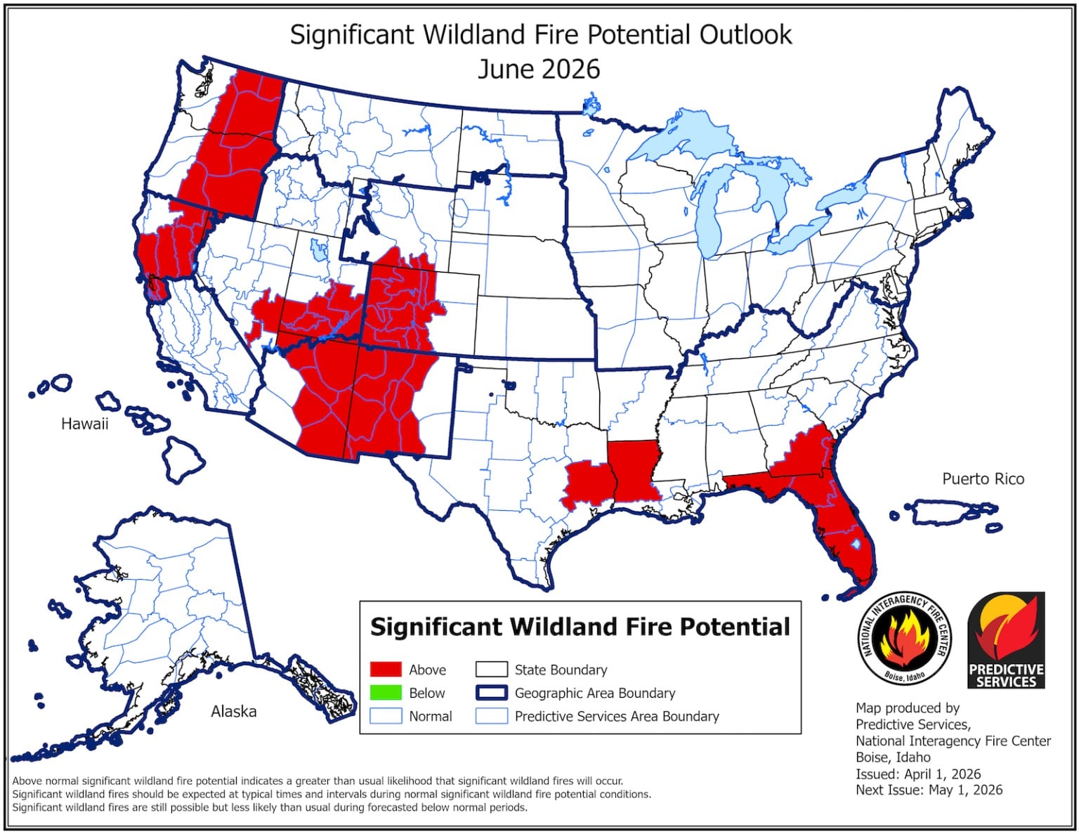
Every state in the West is expected to face an above-normal threat of wildfire this summer, according to the latest projections, released last week by the National Interagency Coordination Center.
The government-run center publishes monthly reports predicting fire risk for the four months ahead, and the change since the March outlook is staggering. The agency denotes elevated risk in red on its maps, and the June forecast from March 2 showed a small swath of rouge in the Southwest. But, citing an ongoing snow drought, rapid snowmelt, and a recent unprecedented heat wave, the latest maps feature red spilling across the Southwest and into the Rockies, Pacific Northwest, and northern California.
“We’re probably not going to be in great shape this year,” said Matthew Hurteau, director of the Center for Fire Resilient Ecosystems and Society at the University of New Mexico. While it’s normal for the Southwest to experience a relatively early fire season, before the summer monsoons hit, what really stood out to him was how quickly the red moved north. “It’s really early for that.”
June typically sees snow lingering in many mountain ranges and snowmelt wetting the landscape, he said. Not this year.
The latest outlook reports that the snowmelt-off in the Four Corners region came “not just several weeks or months earlier than normal, but also four to six weeks earlier than the previously recorded earliest melt-off dates.” The recent heat wave also desiccated the West. Albuquerque, for example, recorded its earliest ever 90-degree reading on March 21, more than six weeks sooner than its previous earliest date, in 1947. The daily average of 73.1 degrees Las Vegas recorded in March would have broken the city’s April record.
Overall, there’s been less snowpack and higher temperatures than pretty much any winter on record. It’s a situation that climatologists have said would be virtually impossible without climate change, and the maps reflect that reality.
“It doesn’t mean that all of these areas are going to burn,” said Alastair Hayden, professor at Cornell University and a former division chief in the California Governor’s Office of Emergency Services. Last year, for example, the Pacific Northwest saw an above-normal risk but was largely spared. Local patterns, such as wind and precipitation, play a major role, too. “But, when I look back at the forecast, fires usually tend to be in one of these locations.”
The one notable spot on the latest maps that seems safe for now is Southern California, though that’s because the fire season there doesn’t usually start until later in the summer, or even into fall. There are also surprising splotches of red, like in Florida, which is experiencing a drought. But the West is by far the largest area of concern. “Keep an eye on July,” said Hurteau. “The Fourth of July is the single highest ignition day of the year.”
The sheer expanse of land that could be at risk simultaneously worries Hurteau. “Our fire suppression apparatus is in part dependent on the whole region not being on fire at the same time,” he said. Fire crews count on being able to hop from hot spot to hot spot. If there are too many at once, resources could run thin.
The number of acres across the country that have burned through March is already 231 percent of the 10-year average. A wet spring, however, could change everything. It recently rained in Albuquerque, where Hurteau is based, and, if it continues, the fire risk could go down dramatically. That’s what happened last year.
“I’m sure that’s what all the fire people are hoping for too, because that would be nice,” said Hurteau. “But hope is not a great strategy.”
This article originally appeared in Grist at https://grist.org/extreme-weather/these-maps-show-exactly-where-the-west-might-burn-this-summer/. Grist is a nonprofit, independent media organization dedicated to telling stories of climate solutions and a just future. Learn more at Grist.org.