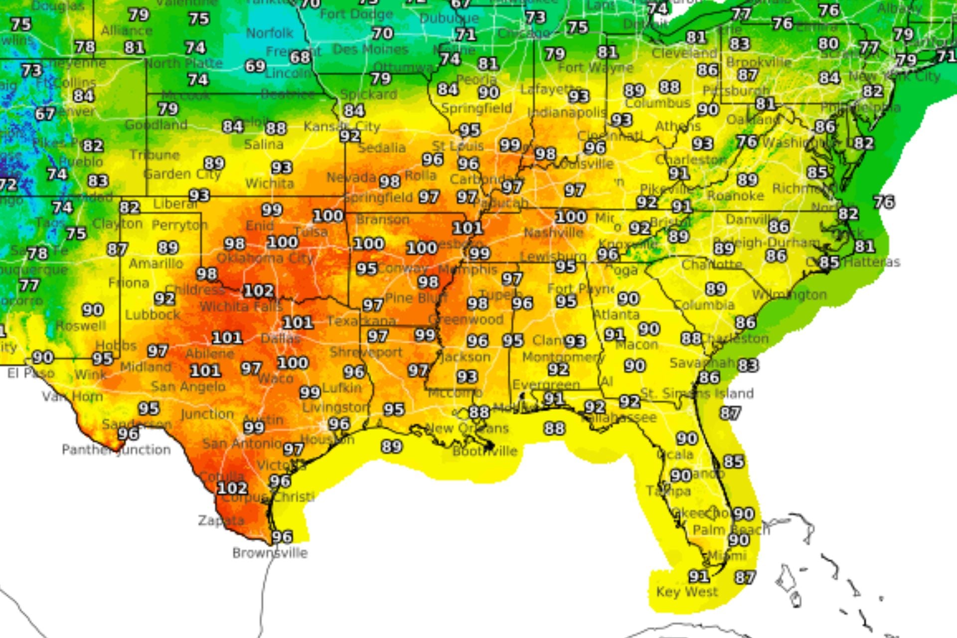
For the past couple of months, a large area of high pressure has squatted over the south-central United States and the Four Corners region, keeping temperatures stubbornly above average. This heat dome has expanded, shifted, and re-intensified multiple times, and now meteorologists say it’s the strongest one on the planet.
Heat advisories currently stretch from Texas and Oklahoma eastward through Arkansas, Louisiana, Mississippi, Tennessee, and Alabama, as well as northward into Missouri, Illinois, Indiana, and Kentucky. In many of these states, temperature records have been shattering.
According to meteorologist Ben Noll, reporting for the Washington Post, there have only been three days since August 3 where Dallas has seen high temperatures below 100 degrees Fahrenheit (38 degrees Celsius). Dallas-based meteorologist Pete Delkus reported Monday that the city broke a record for the most September days with highs above 100 degrees.
In Oklahoma City, daily high temperatures have hit triple digits 11 times in September so far, setting a record for the entire September-to-November period, according to Noll. Wichita has also seen a record-breaking 10 days at or above 100 degrees over that same period.
“Unfortunately, this dome of high pressure has not shown any signs of going anywhere,” meteorologist Alan Gerard wrote in a Substack post on Tuesday. “As weather systems evolve around its periphery, it ‘morphs’ in size, strength and location.” He expects the heat dome to intensify across the mid-South this week and peak by Thursday morning.
Why won’t this heat dome budge?
A heat dome is a large area of high pressure in the middle and upper layers of the atmosphere. All that pressure pushes warm air toward the ground, and as the air sinks, it warms by compression, heating and drying out the landscape. Meanwhile, the dome of high pressure diverts clouds away, preventing storms from cooling the area.
“This can become a self-reinforcing process during the warm season, resulting in stable areas of high pressure that can linger for days or even weeks, resulting in long term heat waves and drought,” Gerard explained.
So what’s causing this dome of high pressure, and why won’t it dissipate? Large-scale atmospheric patterns have consistently favored high pressure over the south-central U.S. these past couple of months. Right now, the ridge remains entrenched over the South, while a slow-moving frontal boundary stretches across the central U.S., separating the hot air to the south from much cooler air to the north.
“Unfortunately, the western end of the front lifting northward means that the hazardous heat is here to stay this week across the South,” the National Weather Service reported today.
Meanwhile, sea surface temperatures in the Gulf of Mexico are exceptionally high, with anomalies approaching 5.4 degrees F (3 degrees C) off the coast of Louisiana, according to Gerard. This is pumping even more heat and humidity into the region and exacerbating the effects of the heat dome.
Noll reports that a “heat dome-halting” cold front could move into the region next week to finally break up the brutal temperatures. But for now, summer will last a bit longer in the south-central United States.