Earth is 4.5 billion years old, and during that time it’s been through a lot of dramatic changes — as well as enormous disasters that reshaped the oceans and continents. Here are ten images that reveal the grandeur of Earth, as seen from the perspective of deep geological time.
(Image via Sebastian)
1. The Burgess Shale
Discovered in the early twentieth century, this hunk of ancient shale (you can see some of it broken up in the foreground) rises up out of the Canadian Rockies in British Columbia. 500 million years ago, it was a rich seabed at the base of an enormous reef system that teemed with life. Really, really weird life — including many creatures unlike anything alive today — whose fossils were preserved in a pristine state due to lucky chance when the reef crumbled. This area gave scientists their first window onto the so-called Cambrian Explosion, when evolution went nuts and produced a wide variety of body types in a short period of time. Think giant shrimp and lots of tentacles. The Burgess Shale reveals an era when multicellular life became the norm, and is in many ways the cradle of life as we know it.
https://gizmodo.com/the-bizarre-life-forms-that-cannot-be-categorized-1245804910
(Images via Burgess Shale Geoscience Foundation.)
2. Shark Bay, Western Australia
What you are seeing are some of the oldest life forms on Earth, stromatolites, who make their home in Shark Bay on the western coast of Australia. Those knobby-looking rocks are actually sand-encrusted layers of algae and bacterial mats, very similar to ones that lived here over 3 billion years ago. Indeed, geologists have discovered the oldest fossilized life forms in the world here. When you slice open an ancient stromatolite sphere, you find layers of billion-year old algae in it that look like tree rings. This is a view onto what Earth life might have looked like just a billion years after our planet was born.
(Image via ABC News)
3. Trinidad State Park, Colorado, USA
See that white line that our friend here is pointing at? That is the layer of ash and liquefied rock that blanketed many parts of the Earth after an asteroid hit the planet 65 million years ago. After it hit, as you probably know, the dinosaurs began to die out. At Trinidad State Park in Colorado, you can see what geologists call the “K-T mass extinction boundary” (K-T stands for Cretaceous-Tertiary) very clearly in several areas where the rocks have been eroded to reveal geological layers in all their complexity. And horror.
https://gizmodo.com/some-dinosaurs-may-have-been-in-trouble-even-without-th-5906966
4. The buried Chicxulub crater in Yucatán, Mexico
Speaking of the K-T mass extinction boundary, here’s the exact site where that 6-mile asteroid hit the planet, off the coast of the Yucatán peninsula. Because the crater is mostly underwater, it had been buried. But scientists scanning the magnetic field discovered this magnetic anomaly (pictured) over the site, caused by the ancient impact and the composition of rocks in the area. Other clues that helped them find the site included higher concentrations of liquified rock, as well as iridium, a metal that is pretty much only found in asteroids.
https://gizmodo.com/dinosaur-killer-asteroid-impacts-are-much-more-common-5905717
5. Siberian Traps, Russia
250 million years ago, a massive volcanic rift opened up in the area now known as Siberia. At the time, it was at the northern tip of a massive supercontinent called Pangaea. The volcano oozed lava and noxious gasses for roughly 1,000 years, eventually releasing as much as 7 million square kilometers of lava, and covering an area roughly the size of western Europe. The emissions from the volcano were so toxic that almost 95 percent of all the species on Earth went extinct (many more than the asteroid impact drove extinct 65 million years ago). Today, you the Siberian traps are what remains of this massive, world-destroying volcano. It’s about 2 million square km of basaltic rock or hardened lava. It looks peaceful and lovely today, but 250 million years ago it was a sea of poison death.
https://gizmodo.com/why-did-nearly-all-life-on-earth-die-250-million-years-5558871
6. The White Cliffs of Dover, England
These incredible chalk cliffs are the result of erosion. But they also revealed the secrets of geological time to naturalists almost 200 years ago. They discovered that they could see different layers in the rock, and that the fossils in each layer were dramatically different. It was one of humanity’s first glimpses of deep time.
(Image by Piotr Kuczynski)
7. Abereiddy, Wales
This beautiful seaside town in Wales is home to a piece of geological history that dates back to the Ordovician period, 470 million years ago. Here scientists have uncovered an enormous number of fossils from sea creatures, especially graptolites, who ruled the planet for millions of years before any animals scrambled up on land. This view could be 470 million years old, with its sparse land plants and incredible oceans.
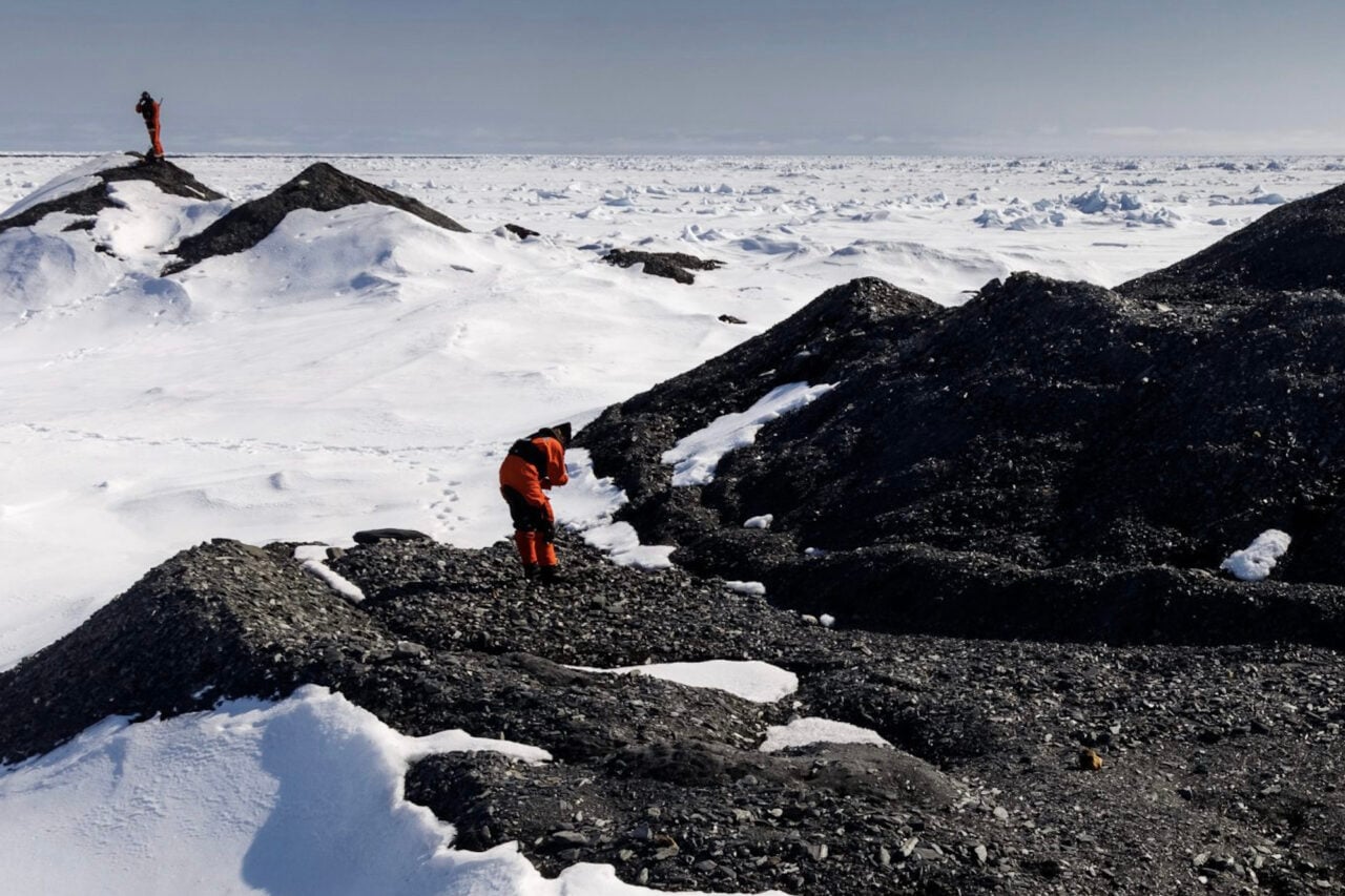
8. James Ross Island, Antarctica
One region of James Ross Island, the Santa Marta Formation, is rich in dinosaur fossils, which proved two important things for geologists. One, it revealed that climate change can be brutal. Antarctica was once a warm, tropical land full of dinosaurs and other incredible animals — and now it is a barren, frozen waste. And two, it offered the most foolproof evidence yet for plate tectonics, the process that moves the continents into new formations on the face of the Earth. There was no way dinosaurs could have gotten to Antarctica unless the continent had once been connected to other land masses, then broken off and floated south.
https://gizmodo.com/the-future-of-antarctica-5790679
(Image via NASA)
9. Central Atlantic Magmatic Province
In this image, taken in Virgina, you can see layers of basaltic rock whose origin tells a dramatic story about the shape of the planet. As we know from the Siberian Traps, basaltic rock is usually the remains of a volcanic outpouring — and this one, from roughly 200 million years ago, is called simply the Central Atlantic Magmatic Province. That’s because it was so enormous that it pushed two continents apart and created the Atlantic Ocean. That’s right — an undersea volcano vomited out enough lava that it eventually pushed North America and Africa so far apart that an ocean grew between them. Now we find the remains of this volcano on the US eastern seaboard, as well as in North Africa. And of course at the bottom of the Atlantic.
10. Olduvai Gorge, Tanzania
We couldn’t tell a story about Earth’s history without including ourselves. Let’s face it — we Homo sapiens love to think that our ancestors’ development on Earth was a pretty important event. At Olduvai Gorge in South Africa, some of our earliest ancestors have been found — including a 1.7 million-year-old Homo habilis, as well as Homo erectus 1.2 million years ago, and finally some Homo sapiens too. This area was once running with water, and full of lush plants. It seems that even a million years ago, we enjoyed warm areas with lots of swimming, food, and cozy caves.
https://gizmodo.com/scientists-unveil-a-newly-discovered-ancient-human-anc-5838487
(Image by Noel Feans)
Annalee Newitz is the author of the book, Scatter, Adapt and Remember: How Humans Will Survive a Mass Extinction. Follow her on Twitter.