Contrary to popular opinion, the Earth is not in fact a round boy nor is it solid rock. It’s a lumpy horror show that can be squished and stretched by relatively weak forces.
Recent findings published in Geophysical Research Letters show that rain associated with tropical cyclones can put a dent in our doughy planet, sometimes as much as a localized earthquake. The research could be used to help improve our understanding of water’s movement as well as mitigate the threat of landslides that can occur in the wake of storms.
The study focuses on Taiwan, which offers a uniquely intimate dataset.
“There you have both the signal and the instruments to measure that signal,” Maxime Mouyen, a geophysicist at the University of Rennes who authored the study, told Earther.
In this case, the signal comes from the 31 typhoons—the local name for a cyclone or hurricane—that hit the island nation between 2004 and 2013. The instruments are the island’s rich network of borehole strainmeters, scientific instruments buried in the ground to monitor seismic and volcanic activity. Those same instruments measure tiny shifts and deformations in the ground using an esoteric (outside the world of geologists anyways) measure of volume known as a nanostrain. One nanostrain represents a volume change equivalent with one part per billion, which is to say its exceedingly small and invisible to the human eye.
These highly sensitive instruments also make them ideal to track the impact of typhoons, which can dump heavy rain locally before it’s funneled off Taiwan’s notorious steep slopes. Because typhoons generally approach Taiwan from the east, Mouyen and his colleagues limited their analysis to three clusters of strainmeters on the island’s east coast and valleys. For the heck of it, the scientists also looked at how much the low pressure associated with typhoons deformed the ground.
What they found shows that typhoons treat the Earth like a trampoline. As the low pressure system passes over, the ground actually expands upward a few millimeters and outward around a millimeter, similar to when you jump off a trampoline.
That expansion was incredibly short-lived, though, and followed immediately by compression associated with rainfall. In some cases, the rain-related strain was more intense than what the drop in air pressure did to the ground. And in all cases, it lasted a lot longer.
Some of the sites also showed a 19-hour delay between when rain fell and when the researchers observed ground compression. The delay indicates that it takes time for runoff to reach areas being measured by strainmeters.
“These measurements are important because they allow us to properly quantify the load of rainwater, which could then be converted into the volume of rainwater that runs off from the mountains toward the valleys,” Mouyen said.
The fact that humans have made instruments advanced enough to detect the tiny ways that storms can deform the planet we live on is some serious “gee whiz” stuff. Also whoa, the planet is a seriously dynamic place. But beyond awe, the results also point to future areas of research that can help improve our lives.
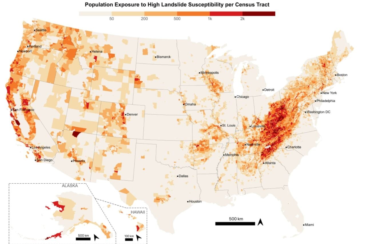
Taiwan is prone to major landslides after storms. By getting a better handle on how rain deforms the land, scientists could help shed light on where the biggest landslides risks are when the next storm hits and potentially get people out of harm’s way.
The West Coast, with its robust network of seismic monitoring, steep terrain and frequent atmospheric river storms, could be another place that would benefit from improved warnings. California’s recent deadly mudslides are only the latest reminder of the dangers extreme weather and the unstable landscape poses to the region.
Christopher Johnson, a seismology postdoc at the Scripps Institute of Oceanography who was unaffiliated with the study, said results like these and others could also be used in water management. Scientists are already using advanced types of radar as well as GPS to monitor changes in aquifers and land. Just a month ago, research came out showing that California’s mountains grew an inch due to the multiyear drought while in the wake of Hurricane Harvey, scientists saw the ground sag nearly an inch under the record-breaking rain.
“Recent studies have used large GPS networks, notably in California, to quantify near surface water storage to monitor the region with a focus on the Sierra Nevada and Central Valley and assess the relationship to earthquake occurrence,” he told Earther in an email. “In this study, the strainmeter measurements, which are recorded 200 meters below the surface, show the potential to increase the resolution of water storage measurements by incorporating additional data into the calculations.”