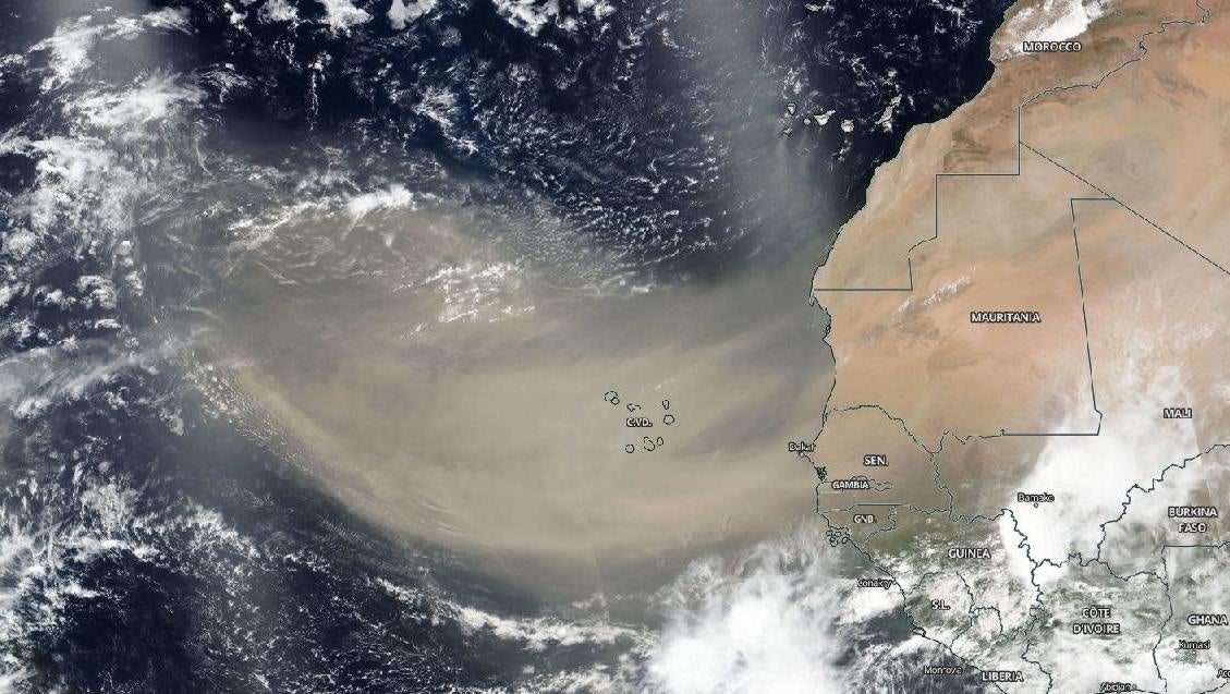
A dust cloud began to drift across the Atlantic last week. It’s a development that could stall the formation of dangerous tropical storms in what’s expected to be an active season, at least for the time being.
A new NASA animation tracks the movement of an unusually large Saharan dust plume over the Atlantic ocean from June 13 to 18. At one point, the plume stretched from the west coast of Africa to the fringes of the Lesser Antilles in the eastern North Atlantic—a distance of more than 2,000 miles (3219 kilometers).
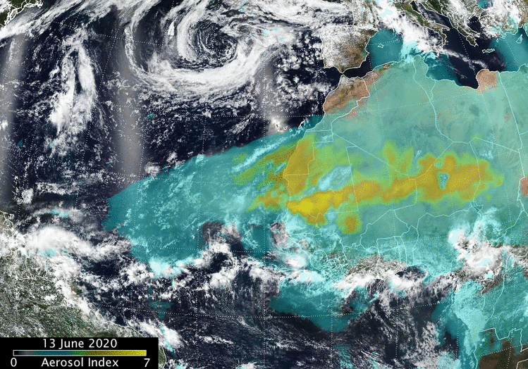
These images were made possible by the Ozone Mapping and Profiler Suite and the Visible Infrared Imaging Radiometer Suite on the Suomi NPP satellite. Strong atmospheric updrafts along the Sahara tossed the fine-grained desert dust up into the sky, where prevailing winds pushed the plumes further to the west. The dust is now making its way into the Caribbean, where it’s affecting air quality.
Meteorologist Ada Monzón tweeted dramatic before-and-after pictures in the mountainous Cayey region of eastern Puerto Rico on Monday. The normally clear view on the southeastern part of the island has been obscured by a dusty haze that descended over the region. On the flip side, vivid sunsets are likely throughout the Caribbean and Gulf of Mexico.
The top image was taken before the #Saharandust event, and bottom image was taken this morning in #Cayey #PuertoRico 📷 Erika Geovanna Quintero #polvodelSahara 🟣 #veryunhealthy pic.twitter.com/LHPVevk4dR
— Ada Monzón (@adamonzon) June 22, 2020
Saharan dust plumes are a natural occurrence. Each year, hundreds of millions of tons of aerosolized dust make the trek to North and South America, pushed along by the trade winds. Much of this dust ends up on tropical Caribbean beaches, but it also helps to fertilize soils in the Amazon rainforest.
Importantly, these plumes also influence the production of tropical storms and hurricanes. Normally, the atmosphere around a mile up is quite moist, but these sands are accompanied by dry desert air, creating an environment in which it is difficult for storms to form and strengthen.
The 2020 Atlantic hurricane season has already produced three named storms—tropical storms Arthur, Bertha, and Cristobal—but all this dust could stall things for a while. But dust now is not necessarily a sign of things to come. A dusty start to the 2018 Atlantic hurricane season, for example, was followed by unusual intensity, including damaging hurricanes Florence and Michael. With the peak of hurricane season still months out, there’s still unfortunately time to clear the air.