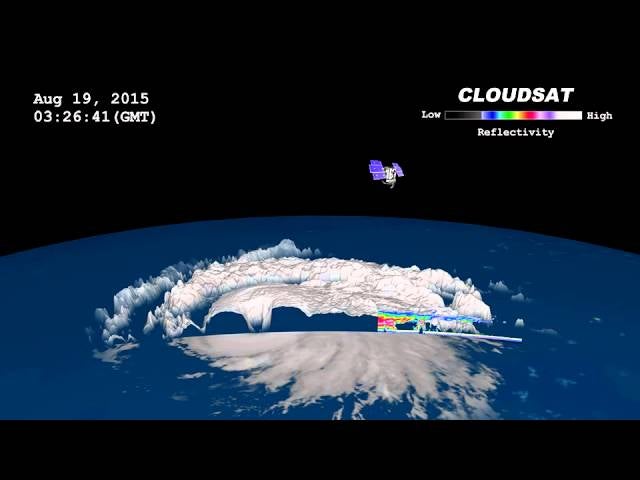
Atsani is the the sixth super typhoon to make an appearance during the 2015 West Pacific Tropical Season, which already surpassed the normal average of four. Prior to achieving its super status, CloudSat’s imager collected information about the storm, allowing for this incredible cross-sectional view.
Atsani’s current trajectory puts it on a collision course with Japan, but the latest projections indicate that it will soon veer east and miss it altogether.
Geostationary imagery of Super Typhoon Atsani (U.S. Naval Research Laboratory).
Tropical cyclone warning graphic of Super Typhoon 17W (Atsani) from the Joint Typhoon Warning Center.
There is still concern, however, of the storm’s effects on the region. As of today (August 21), Atsani is ranked a Category 5 super typhoon, attaining one-minute sustained winds of 160 mph (260 km/h).
An animated satellite image showing Atsani tracking across the Pacific Ocean (Credit: NOAA).
Two days ago, CloudSat passed over its eye and used its cloud-penetrating radar to scan the storm.
This allowed scientists to create a cross-section that shows what the typhoon would look like if were dissected. The folks at NASA’s Earth Observatory took a photo captured by MODIS on the Aqua satellite (below) to provide reference.
Typhoon cross-section (Credit: Jesse Allen, using CloudSat data provided courtesy of the CloudSat team at Colorado State University).
Here’s a zoomed-in view of the super typhoon’s eye:
NASA explains:
In the CloudSat data, the darkest blues represent areas where clouds and raindrops reflected the strongest signal back to the satellite radar. These areas had the heaviest precipitation and the largest water droplets. The blue horizontal line across the data is the freezing line; ice particles formed above it, raindrops below it. CloudSat passed just west of the eye, offering a good view of the storm’s outward sloping eyewall, intense convection and rainfall, and cloud structure. Atsani’s clouds reached about 16 kilometers (10 miles) altitude at their highest point. When CloudSat imaged the storm, Atsani’s maximum sustained winds were about 150 miles (240 kilometers) per hour.
Areas of pink and red indicate larger amounts of liquid and ice, while light blue indicates smaller cloud droplets (Credit: NASA/Colorado State Univ., Natalie D. Tourville).
Since the start of its mission, Cloudsat has imaged about 1,200 hurricanes and typhoons—but this is only the 30th time it has been able to capture data of a major storm’s eye.


