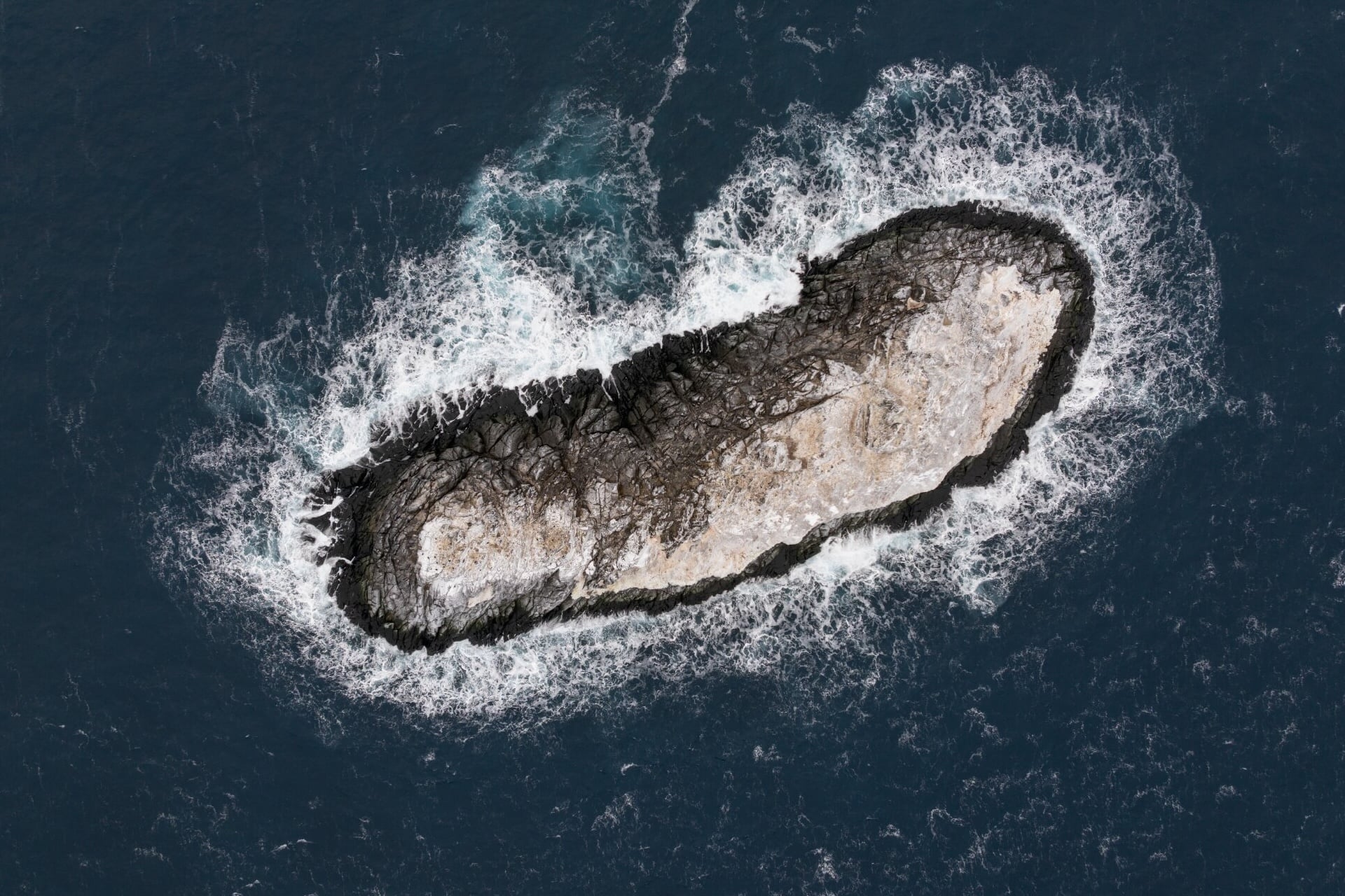
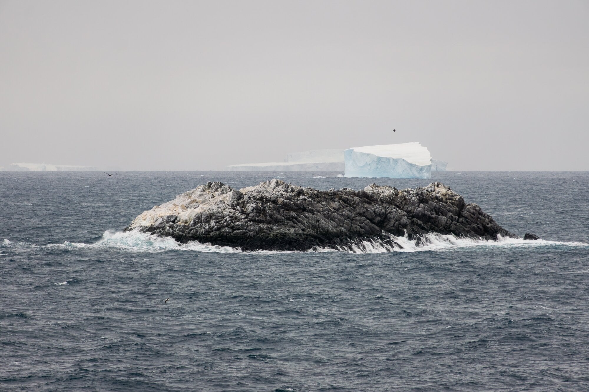
On satellite images, it was virtually indistinguishable from the flotilla of icebergs drifting around it. When approached from the horizon through the Antarctic’s Weddell Sea, it even looked like one, just coated in a layer of muck and ocean grime. But scientists with the Polarstern expedition have now identified it as a previously uncharted island.
The island—which is roughly the size of the White House (about 66,740 square feet, or 6,200 square meters)—does not have a name yet, according to the Alfred Wegener Institute’s Polarstern team. The newly discovered island has now been completely surveyed, and its precise geographic coordinates will soon be added to international nautical charts and other critical datasets.
Up until this year, the island’s location had been misidentified by about one nautical mile and ambiguously defined as a “danger zone” to mariners on nautical charts, per an AWI press statement. The mystery intrigued geophysicist Simon Dreutter, whose research role on AWI’s Polarstern icebreaker vessel involves collecting and analyzing bathymetric data, here meaning the topographical undersea mapping of ocean floors scanned via sonar, blue-green laser LiDAR, and other tools.
“The nautical chart showed an area with unexplored dangers to navigation, but it wasn’t clear what it was or where the information came from,” Dreutter said in a statement.
“I scoured all the coastlines we had here in the bathymetry lab [databases] and went back to the bridge,” the researcher continued. “Looking out of the window, we saw an ‘iceberg’ that looked kind of dirty. On closer inspection, we realized that it was probably rock. We then changed course and headed in that direction and it became increasingly clear that we had an island in front of us.”
For those about to (identify a) rock
The Polarstern and its 93-person team of international scientists, technicians, and crew had been dispatched by AWI’s Helmholtz Centre for Polar and Marine Research to track ice and water flow from Antarctica’s melting Larsen Ice Shelf when it discovered this uncharted island. The team has been exploring in the Weddell Sea northwest of Antarctica since February 8, 2026, until a bout of deadly storms had forced them to seek shelter behind Joinville Island—an icy outpost on the tip of the Antarctic Peninsula, close to the aptly named Danger Islands. They spotted the uncharted island on their way to safety.
Bathymetric data collected by Dreutter and others later helped the crew navigate the Polarstern to a safe distance from this uncharted isle, from a patch of nearby ocean with at least 50 meters (164 feet) of water under the ship’s keel. At a distance of 150 meters (492 feet) from the island, the icebreaker ship circumnavigated this previously unknown landmass, surveying the seabed with an onboard multibeam echo sounder, a type of sonar that yields high-resolution 3D images. The team also sent up an imaging drone to collect elevation data and coastline measurements via classic photogrammetric methods.
The as-yet-unnamed island (which I can’t stop you from attempting to name in the comments below) ascends about 52 feet (16 meters) from sea level at its highest. It proved to be just a little bit longer than the Polarstern itself, about 427 feet (130 meters) long compared to the icebreaker’s 387 feet (118 meters), and twice as wide at 164 feet (50 meters).
Undersea mountains, polar meltwater, and climate change
It’s still unclear whether local ice melt due to climate change might have been a key factor in revealing the new uncharted island. However, the Polarstern team has reported that summer sea ice across this northwestern region of Antarctica’s Weddell Sea has been verifiably smaller and less numerous since 2017, “presumably as a result of warmer surface water,” according to AWI.
The newly discovered island is not the first time the Polarstern has contributed to the global nautical charts. In 2014, the head of AWI’s bathymetry team, Boris Dorschel-Herr, discovered, plotted, and reported two underwater mountains, one in the South Atlantic and another in the Weddell Sea.
Just to get the creative juices flowing, before an official name for this island is added to IBCSO (International Bathymetric Chart of the Southern Ocean), here are a couple names that have already been taken for past landforms around the Antarctic: “Elliot Rocks,” “Minotaur Pass,” “West Groin,” and the now inaccurately named “Final Island.”