Rounds of violent thunderstorms are set to lash a large swath of the country this week, bringing an elevated risk of severe weather and possible tornadoes to tens of millions.
Parts of the central U.S. have already been hit hard. According to preliminary numbers from the National Weather Service Storm Prediction Center, a severe weather outbreak produced at least 15 tornadoes across Wisconsin, Minnesota, Iowa, and Kansas on Monday. Reports suggest Ottawa, Kansas, was among the hardest-hit areas. Local officials said three people suffered minor injuries, most of the town lost power, and school was canceled today due to a tornado that swept through the town Monday evening.
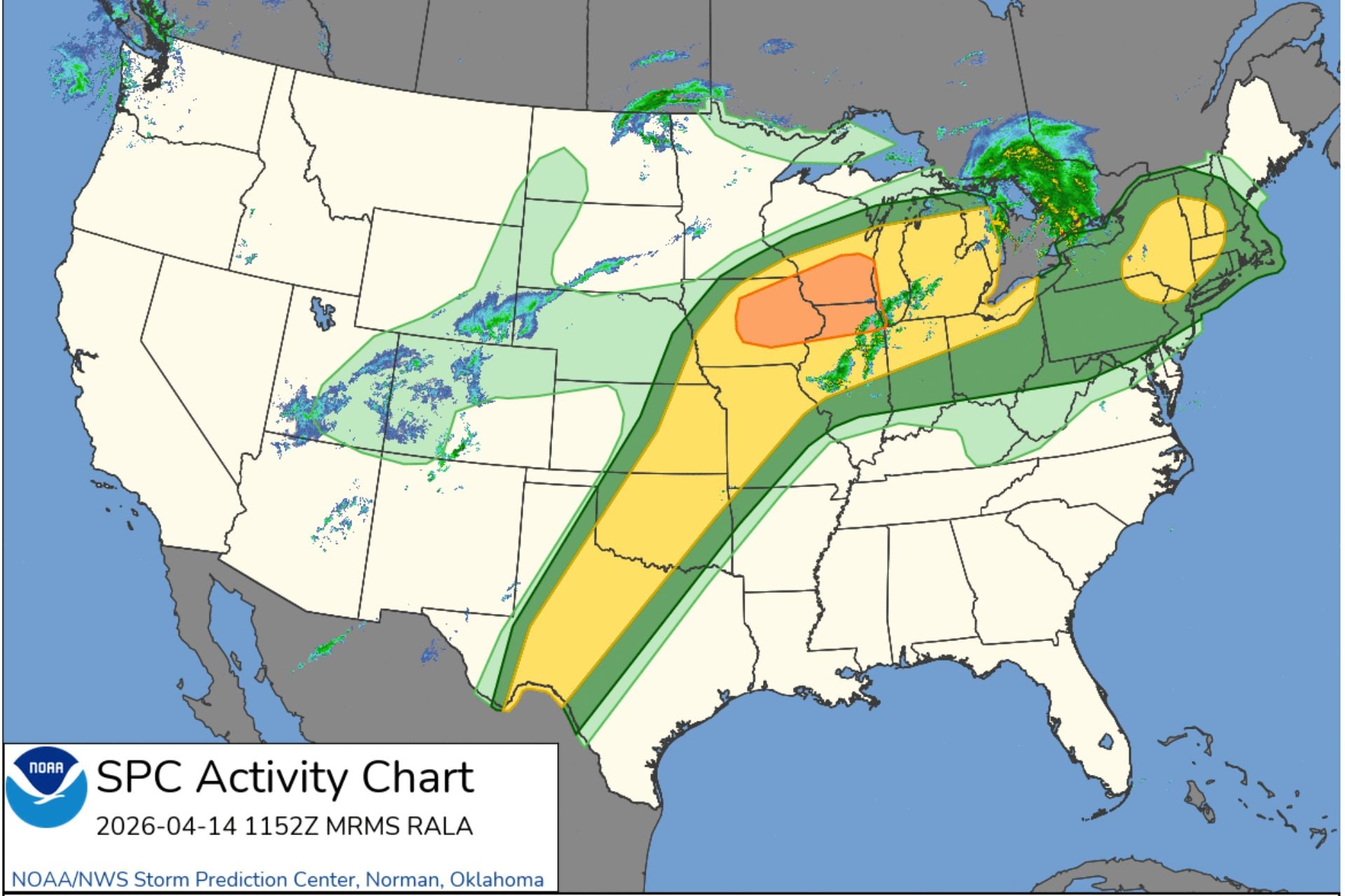
Forecasters expect the threat of severe weather to continue through the rest of the week, expanding into the Great Lakes, the Ohio Valley, and the Northeast. The NWS said these storms will likely become a daily occurrence as they track west to east along a northern tier storm front.
Wild weather fueled by record heat
In the central and southern Plains, moisture flowing in from the Gulf of Mexico will fuel additional rounds of strong to possibly severe thunderstorms with heavy downpours today, according to the NWS. Forecasters expect these storms to extend northeastward across Missouri and into the Midwest, becoming more active during the afternoon and overnight hours.
The strong ridge of high pressure that’s feeding moisture into the Great Plains will also bring unseasonable warmth to the eastern U.S. According to meteorologist Ben Noll, the Mid-Atlantic will experience some of the highest temperatures in the country this week.
The Mid-Atlantic will experience some of the hottest conditions in the U.S. this week as summer-like warmth spreads east.
We'll see just how hot it gets in D.C. on Wednesday and Thursday. The April record there is 95 degrees. pic.twitter.com/cxeeA4PfWp
— Ben Noll (@BenNollWeather) April 13, 2026
The NWS predicts that high temperatures will climb into the 80s Fahrenheit (high 20s Celsius) and begin to challenge daily records across the east-central U.S. by this afternoon. By Wednesday afternoon, the Mid-Atlantic could see record-high temperatures reaching into the 90s Fahrenheit (30s Celsius). This heat wave should persist through Thursday.
Areas at greatest risk of tornadoes today
According to the Storm Prediction Center, roughly 32 million people are within areas of elevated tornado risk today. The risk zone includes major cities such as Madison, Wisconsin; Chicago, Illinois; Detroit, Michigan; Oklahoma City, Oklahoma; and Wichita, Kansas.
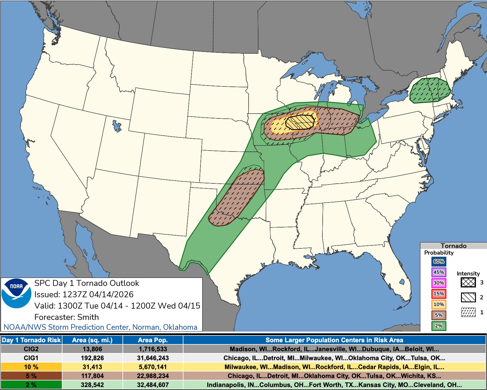
More than 1.7 million Americans are within an isolated zone of strong tornado risk that covers portions of southern Wisconsin, eastern Iowa, and northern Illinois. Larger population centers within that area include Madison, Janesville, and Beloit, Wisconsin; Rockford, Illinois; and Dubuque, Iowa. There is also a threat of “large to giant” hail from Iowa to the southern Great Lakes and from Kansas into Oklahoma and Texas.
Tornado risk should decrease significantly by Wednesday, and forecasters expect Thursday to offer a brief reprieve from strong thunderstorms. However, parts of the southern Plains to the upper Midwest could see another round of severe weather on Friday ahead of a strong cold front expected to track across the country. Severe storms could continue to impact parts of the Great Lakes, Ohio Valley, and the South over the weekend before this violent pattern finally comes to an end early next week.
Over the course of the week, be sure to monitor your local forecast as the storm threat evolves.